The trip to Villa de
Leyva had helped us to iron out our packing and we initially did a great job
but at the last minute we added a few things each to the bags which made them a
bit too full for my liking. My yellow
drybag weighed in at 14.8 kg, each saddlebag weighed 7.75 kg, and the tankbag
weighed 2.4 kg for a total luggage weight of 32.7 kg. This was carrying very little food and only 2
liters of water. When we start to get to
more remote areas we will be carrying much more food and water which will add
more than a few kg to the load. The
weight itself is tolerable but it is good to have the bags only partially full
for ease of packing and to give us more flexibility as we figure out what we
actually need. One of the biggest
struggles when packing was trying to figure out what type of trip this would
actually be. How much will we camp
versus stay in hotels? How much will we
actually cook? How much time will we be in hot climates versus cold climates? I expect that we will camp and cook more as
we make it into more expensive countries like Chile, Argentina, and
Brazil.
The trip to Villa de Leyva
also made me realize how uncomfortable the factory handlebars were on the
Tornado. They were too narrow and had
too much sweep (how much the handle grip portion angles back towards your
body).
I changed the bars for some Pro
Taper EVO CR High bend fatbars from the USA but got the wrong clamps to attach
my handguards. I was unable to find the
right clamps in Bogota but during my search found out that Bogota is FULL of
fake ProTaper products. The quality of
the ProTaper bars that I saw looked terrible so I asked in a shop and the guy told
me that ProTaper had not been trademarked in time in Colombia so there is now a
Colombian company making all manner of ProTaper products.
I was able to find some Renthal RC High bars
which fit perfectly with my handguards and have much better ergonomics for me. I had to take off my bar risers as the
factory throttle cables are not long enough for both the high bars and the 30mm
risers.
After our previous
¨soft start¨ to from Bogota to Villa de Leyva and back we finally got on the
road for a real a week later, on September 22nd. We headed in the direction of Llanos Orientes
(the Eastern plains). We are still
figuring out how much distance we can really plan for in a day and it greatly
depends on the quality of the roads. We
are planning routes with the GPS using Garmin Basecamp and are picking dirt
roads but it is impossible to tell if the road will be a hardpack gravel road
or a washed out riverbed with softball size rocks, mud, and loose sand. Even
when we choose a paved secondary road the pavement is usually sporadic and
there are often landslides or large washed out portions of the road. Perfect territory for endure motorcycles.
We started at 11:00
and were in Guateque in time for a coffee break.
 |
| Guateque |
Along the way we passed a lot of small towns perched the the mountains that were sometimes only visible due to the church steeples.
 |
| We saw a number of small towns perched alone in the mountains. Seen between Bogota and Guateque. |
 |
| Second town, somewhere between Guateque and La Represa del Chivor. |
We passed
through a lot of tunnels which were bare stone on the inside and thus while it
was dry outside it was ¨raining¨ inside the tunnels.
We were nearing Santa Marta in the late afternoon when we passed a small restaurant called Los Clavellinos
with a sign for EcoTours and camping.
The owner offered to let us camp for free for the night if we bought some food and
drinks. Deal. We camped
in a marshy spot with an amazing view of the Represa de Chivor.
The scenery reminds me of New Zealand with green mountains and valleys and small waterfalls all over the hillsides.


On September 23rd
we left Los Clavellinos with an intended destination of Yopal. Following the recommendation of the owner of Los Clavellinos, We took a detour from la Via Chibor and went through a side tunnel to an amazing waterfall.
 |
| Tunnel entrance. This was one raining inside and outside |
As there is a hydroelectric plant and a large dam in the area these is also a significant military presence. Three young soldiers checked our documents and examined our bags. They were very interested in the bikes and the gear and one of the soldiers said ¨aqui tienen toda para cambuchear!¨ and the other soldier quickly corrected him to say ¨no se dice cambuchear se dice acampar¨. Cambuchear is now my favorite Spanish word. A cambuche is like a shanty in Spanish so the soldiers were saying that we have everything to set up our own shanty, which is really what camping is.
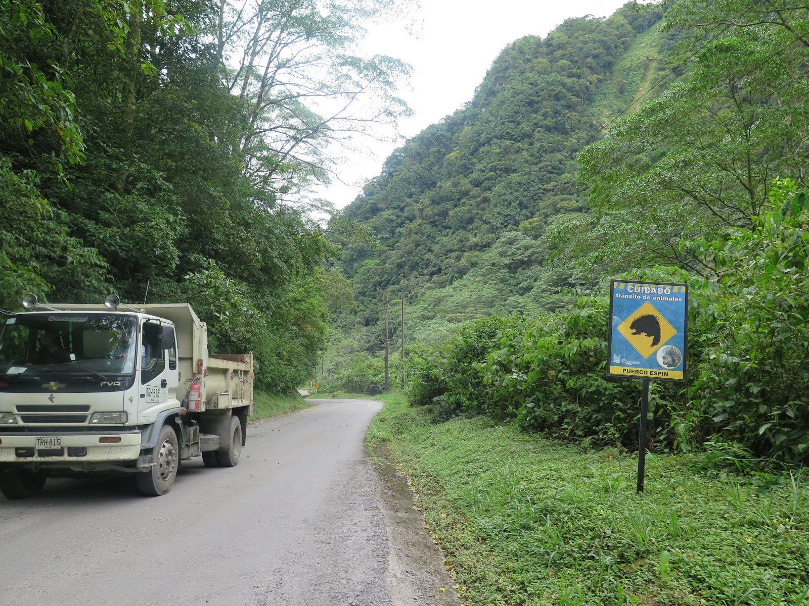
 |
| Puercoespín = Porcupine |
Route 56 was a nice road with a mix of
pavement, hardpack and some gravel with a bit of mud.
 |
| A good sign |
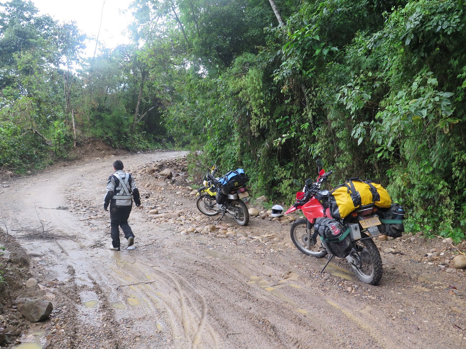
Carolina didn’t have her rain gear well
strapped down and it disappeared at some point before Aguazul. I went back around 25km looking for it with
no luck. The raingear was in a black bag
and you would not believe how many black plastic bags of trash there are
alongside the road.
 |
| Carolina in some "trocha" or alternatively titled "the last time anyone saw Carolina's rain gear" |
When we finally got
close to Aguazul traffic was backed up for a kilometer before the bridge
leaving to the town. We filtered to the
front of traffic with the rest of the motorcycles and sat for 15 minutes
watching construction workers use water to fill plastic barriers which would
reduce the bridge from one to two lane.
The workers were just starting when we got there it and it was clear
that it was going to be a while. There
were two policemen on motorcycles riding from one side of the bridge to the
other trying to control traffic on both ends.
There was a construction worker holding a stop sign at each side which
seemed totally inadequate to control impatient Colombian traffic. There was constant honking and every few
minutes one of the motorcyclists would rev up their engine and ¨test¨ the
construction worker to see if he would really try to stop them. Carolina fell for one of these attempts and
thought traffic was actually moving and swerved around the stop sign and
crossed the bridge. She was the only one
to go across. I waited another 15
minutes until they totally lost control of traffic and 50 motorcycles crossed
at once. This bridge however, was only
the first obstacle.
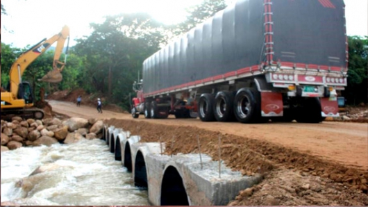
We knew that the
bridge leading into Yopal had collapsed weeks ago when too many heavy trucks
tried to cross it at once (likely the reason for them reducing the bridge at
Aguazul to one lane).
 |
| Bridge at Yopal. Too many heavy vehicles at one. Photo from http://www.eluniversal.com.co/sites/default/files/201608/caida_de_puente.jpg |
We had heard that
there was a temporary bridge in place but as we neared Yopal traffic was backed
up for kilometers. We filtered to the
front and talked to the police (there were plenty at this bridge) who said that
it was raining in the hills and thus the Rio Chater had risen and the bridge
was closed.
 |
| Waiting to see if they will open the bridge across the River Chater |
 |
| Police barricade at the Rio Chater |
They couldn't say when it would be open again for sure but they guessed that it would not be until the next morning. This left the option of waiting at the bridge of returning to Aguazul and looking for a place to stay, likely along with the hundreds of other people waiting at the bridge. There were small boats taking pedestrians and people that had abandoned their vehicles across but we didn't want to leave the bikes. We talked to the owners of a small store near the police barricade and they said that we could camp there for the night.
 |
| Slept inside this store for the night |
There was not a good
spot to set up the tent as unfortunately our tent needs to be set up with
stakes and will not stand up on its own.
This was not the first time that this had gotten us and I was already
cursing this tent. We settled in at the
store for a dinner of TodoRico and Gatorade as night fell. At about 21:30 there was a commotion and some
motorcycles went flying past the checkpoint.
They had temporarily opened the bridge going into Yopal. We had already taken everything off the bikes
and Carolina really didn’t want to hurry to cross. The window was quite small as they would
surely shut it again in a few minutes so we decided to wait until morning to
cross. The owners let us sleep on the
floor of their house, which was attached to the store, which was a much better
alternative to setting up a tent in a dark parking lot that would be full of
traffic all night. It poured during the
night and we were doubly glad to be inside.
In the morning were up
early and had coffee and caldo de costilla while waiting for the bridge to be
opened. It finally opened to motorcycles
around 08:30 and we finally got to see the bridge. Unfortunately due to the rush of traffic and
the sketchy conditions we were unable to take any pictures. When we finally saw the replacement bridge it
was obvious what the hold up was. The
bridge was an earthen dam the river with 4 (?) huge concrete culverts embedded
in it to let water pass. Rising water
could easily top the bridge and even under normal conditions the bridge needed
constant work. For this reason only
motorcycles were being allowed to pass at the time. If I understood correctly there were two
temporary bridges, one for heavy vehicles and one for light vehicles.
 |
| Temporary bridge. I could have sworn the one we crossed has less concrete tubes so maybe this is the heavy vehicle one? (http://imagenes.canalrcn.com/ImgNoticias/styles/530xauto/s3/s3fs-public/noticias/yopal_0.jpg?itok=Z2l-x5SE) |
 |
| Trucks lined up waiting on the other side of the bridge |
Once we got to Yopal
we called some of Carolina´s relatives and they gave us directions to their
ranch which was near a town called Tilo, south of Yopal. It was 27C / 80 F and we were dying in the
motorcycle suits. The llanos were hot
and dry and the scenery was beautiful.
When we got to the
ranch we struggled more than we should have to get the gates open. Every task becomes more frustrating than it
needs to be when you are wearing the equivalent to a snow suit in the
heat.
Libia and Robinson
offered cold showers and cold lemonade right off the bat and we happily changed
out of our moto gear. They have cebu,
chivos, pigs, chickens and horses. We
had fresh chivo (which is not a bearded goat as I was picturing but rather a
variety called camuro which sounds suspiciously like kangaroo) and enjoyed learning about the cattle business. I also learned that ojos zarcos (blue eyes)
are bad luck in the llanos.
 |
| Melcocha (dessert made from panela) that Libia was making |
 |
| With Robinson and Libi |
 |
| Loros |
 |
| Chickens |
 |
| Chivos (canawaru) |
 |
| Cebu |
 |
| Breakfast! |
We woke up later than intended the next morning and after breakfast got on the road back to Yopal with an intended destination of Laguna de Tota. We stopped in Yopal quickly and Carolina bought new plastic rain gear to replace her lost gear. The road was paved from Yopal to El Morro at which point the pavement ended and the road got progressively rougher. Carolina had a few "offs".
 |
| Carolina walking away from the crash and removing her helmet for effect, waiting for the Hollywood explosion |
 |
| Getting amped up for the next section. |
 |
| Off again. Time to mentally regroup |
About 20 minutes after El Morro it started to rain. Light rain as first but as we continued it got heavier. By the time Carolina put her rain gear on she was already pretty wet. My jacket and pants are Goretex so it this was not as much of an issue for me. However, waterproof is a relative term when it comes to clothing and going slow and stopping a lot the rain has plenty of opportunities to get down your collar, up your sleeves and into your helmet.

We were getting close to our next "checkpoint" of the day which was Quebrada La Almorzadera. A quebrada is a gorge or ravine and we knew that there was a water crossing there. The increasing rain had us worried about how tough this crossing would be. It is worth noting that Carolina and I have different recollections of this day. She is a relatively new rider and very new at riding offroad. This road was at the limit of her comfort level already and the rain and the specter of the quebrada hanging over her head were leading to an increasing panic. I was taking in the view and enjoying this immensely as this was exactly the riding that I was hoping for with this trip. Carolina remembers that it was pouring rain the second that we left El Morro but the pictures are more in agreement with my memory.
With the stage set, as we continued in the rain we passed a 4wd truck and two motorcycles going on the other direction. The truck driver yelled out the window as he passed "no hay paso!" or you can't get through. We stopped the motorcycle riders and the assured us that we could get through with both of us walking each bike across together.
 |
| Starting to rain |
We rounded a blind corner and got our first view of Quebrada La Almorzadera and it did not look good. I had my head full of some public service announcement from I don't know where that rushing water at shin level of above could carry you away and this water definitely had a ferocity far exceeding that.
 |
| Notice the suicidal bicyclists |
The driver of this truck told us he was going to wait it out, as he needed to get through and the water would drop. As the rain had only been increasing I was struggling to imagine that the water level would drop anytime soon but we decided to go with local wisdom and wait for a bit.
The bicyclists were not going to wait. They were crossing the very partially built bridge on foot, which seemed like a terrible idea. We saw a number of them cross with no issues.
 |
| Locals waiting to cross. |
Some more motorcycles arrived and were waiting with us Notice that while we are often proud of ourselves for making it down some "tough" road on our enduro bikes there are always locals flying down that same road on worn out 100cc bikes and scooters with no suspension and bald tires.
At this point it was 16:30 and we had about an hour until darkness. We needed to make a decision whether to stay and wait it out (more likely until morning) or head back to Yopal. The road the entire way from El Morro had been narrow and I hadn't seen anywhere big enough to park safely off of the road and set up our tent. Additionally we had seen evidence of a lot of landslides and setting up the tent beside a hill in the heavy rain seemed like a bad idea. I wanted to head back to town and find somewhere dry for the night. The final complication was that weren't carrying very much food and were both already hungry
 |
| El Cambuche |
We set up a tarp on some ramps nearby and we sat in relative dryness while eating some crackers and peanut butter and considering options. Carolina did not want to turn back as she was afraid that the condition of the road (and one particularly steep and long rocky hill) would have deteriorated a lot in the rain and would be a difficult ascent.
Eventually the locals waiting with us gave around and turned back for El Morro which gave us enough of an impulse to turn back. Carolina was not happy with the decision but the alternative was also not appealing.
It turned out to be much ado about nothing and 20 minutes later we were back in El Morro drinking hot coffee and eating morcilla.
 |
| Two coffees please!... actually better make it four. |
We called Libia and Robinson and they offered us their home in Yopal so after very slightly drying off we headed back to Yopal.
Andrew